Major LAND FORMS
"Jamaica is the third largest island in the Caribbean, after Cuba and Hispaniola. It's mostly mountainous, with a narrow, discontinuous coastal plain.
The island is ringed by numerous bays, small cays and islands, and white-sand beaches stretch for miles in some areas.
Volcanic in origin, Jamaica can be divided into three landform regions: the eastern mountains, the central valleys and plateaus, and the coastal plains.
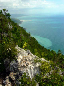
-Blue Mountains(the eastern mountains) range in eastern Jamaica that extends for about 30 miles (50 km) from Stony Hill, 8 miles north of Kingston, eastward to the Caribbean Sea. The highest point in the range is Blue Mountain Peak (7,402 feet [2,256 metres]). The Blue Mountains are thickly covered with tree ferns. The slopes facing the trade winds receive an average of 200 inches (5,000 mm) of rain annually, resulting in much topsoil erosion and a network of streams. Winter temperatures generally may fall to 45 °F (7 °C), but frost and sleet have been experienced on Blue Mountain Peak. Coffee, formerly grown on large plantations, is cultivated in the valleys by peasants. It is among the most expensive coffees in the world and is exported mainly to Japan. Other mountain ranges of note include the John Crow, Dry Harbour and the southern Manchester Plateau.
-The limestone plateau covers two-thirds of Jamaica, and there caves, caverns, sinkholes and valleys and scattered about in large numbers.
-To the west of the mountains is the rugged terrain of the Cockpit Country. It is a harsh, dramatic landscape filled with endless hills.
-As for rivers, there are over 100 in Jamaica, however, most are small, unexplored and not navigable; many are mostly underground rivers and run through the limestone region.
-The Black River is the largest (widest) river at 73 km long. The Rio Minho is the longest river in Jamaica."
The island is ringed by numerous bays, small cays and islands, and white-sand beaches stretch for miles in some areas.
Volcanic in origin, Jamaica can be divided into three landform regions: the eastern mountains, the central valleys and plateaus, and the coastal plains.
-Blue Mountains(the eastern mountains) range in eastern Jamaica that extends for about 30 miles (50 km) from Stony Hill, 8 miles north of Kingston, eastward to the Caribbean Sea. The highest point in the range is Blue Mountain Peak (7,402 feet [2,256 metres]). The Blue Mountains are thickly covered with tree ferns. The slopes facing the trade winds receive an average of 200 inches (5,000 mm) of rain annually, resulting in much topsoil erosion and a network of streams. Winter temperatures generally may fall to 45 °F (7 °C), but frost and sleet have been experienced on Blue Mountain Peak. Coffee, formerly grown on large plantations, is cultivated in the valleys by peasants. It is among the most expensive coffees in the world and is exported mainly to Japan. Other mountain ranges of note include the John Crow, Dry Harbour and the southern Manchester Plateau.
-The limestone plateau covers two-thirds of Jamaica, and there caves, caverns, sinkholes and valleys and scattered about in large numbers.
-To the west of the mountains is the rugged terrain of the Cockpit Country. It is a harsh, dramatic landscape filled with endless hills.
-As for rivers, there are over 100 in Jamaica, however, most are small, unexplored and not navigable; many are mostly underground rivers and run through the limestone region.
-The Black River is the largest (widest) river at 73 km long. The Rio Minho is the longest river in Jamaica."
